𝗦𝗵𝗶𝗽𝗿𝗮 𝗗𝗲𝗼, 𝗠𝘆-𝗟𝗮𝗻 𝗗𝗼𝗱𝗱, 𝗮𝗻𝗱 𝗝𝗲𝗻𝗻𝗶𝗳𝗲𝗿 𝗕𝗿𝗼𝘄𝗻
4 min read


Viljar Peep
13 min read


Dr. Shivangi Somvanshi
5 min read


Image Courtesy: Geospatial World
The development of a good Land Administration System is crucial for securing the land tenure of the people. It also contributes to achieving a vibrant national economy. Land administration relates people to land and informs on the ‘how’, ‘what’, who’, ‘when’ and ‘where’ of land tenure, land use, land value, and land development. Land administration systems are the basis for recording the complex range of rights, restrictions and responsibilities related to people, policies and places. Effective land administration must be fit-for-purpose, appropriate, adequate, interoperable, sustainable, flexible and inclusive. It should be able to document, record and recognize people-to-land relationships in all its forms.
Land administration is a continuous flow of several activities to modernize land records and reduce disputes. Using geospatial technology, one can streamline workflows and enforce cadastral procedures correctly through efficient job management and integration of maps and textual records.
The novel technologies, which are most likely to affect and possibly disrupt current functions and processes of spatial planning and land management, include machine learning, Lidar, BIM in connection with GIS, Blockchain, Big data analytics, Extended, Immersive and Mixed Reality, different types of operational research and digital twins. These technologies are better equipped to handle dynamic uncertainties. The prime advantages of using these novel technologies are:
Possibilities of faster and more accurate analysis
Decreased dependence on centralized storage of data
Easier and more democratized access to analytical functions and algorithms
More automated integration of technologies and services.
Figure 1 below demonstrates different technology trends that can influence and impact various functions under land administration:

Figure 1: Technology Trends in Land Administration and Management
(Source: Geospatial World Analysis)
Creating and maintaining an effective land administration system is an intricate process managed by various agencies and organizations. Geospatial technology and applications are being used for several aspects of the land administration workflow. Changes in land management practices, regulations and operations have frequently relied on the uptake of innovations in geospatial technologies. However, the impact of geospatial technology adoption will be realized effectively only when it is applied across the entire workflow of a land administration system. The workflow of land administration and management is demonstrated below in Figure 2, along with the geospatial component at each stage of the workflow.

Figure 2: Workflow of Land Administration and Integration of Geospatial Technology
(Source: Geospatial World Analysis)
There are various types of functions and aims of geospatial adoption in land administration workflow, and the execution of interventions typically takes place in a consecutive,interactive,and integrated manner. Some of the key land management functionsare mentioned below in Figure 3 with spatial planning aspects also included.

Figure 3: Functions and aims of spatial land interventions.
(Source: Geospatial World Analysis)
Stakeholders of the land administration ecosystem include surveyors, private geospatial industry, land and cadastre agencies, policymakers, and communities. They have embraced innovations of the 4th industrial revolution and are evolving and adapting to use geospatial and frontier technology across the workflow. Types of geospatial technology adopted for different functions in land administration and management are demonstrated in Table 1.
Table 1: Functional categories of geospatial technologies that are relevant for spatial planning and land management.


The maturity of the land administration ecosystem can be modelled across four levels as demonstrated in Figure 4. The model forms a kind of ladder where every step gives higher value and efficiency. The model has four stages: Standard, Connected, Integrated and Networked. Once the standard level is met, different organisations, start to make a connection. A point-to-point connection creates possibilities to exchange land administration information, both geographic and administrative. After being connected, they start acting as a whole. This will form a kind of Land Administration Information Infrastructure; the spatial information “hang-out” for all related users. The ultimate level ‘network’ implies a mind shift and has the biggest effect. The focus will shift from the land administration towards higher-level social themes. Within these themes, many different players (stakeholders) and sectors and information sets must work together to face the social challenges. This will require semantic translations of the information to be useful in a different context than the original production purposes.
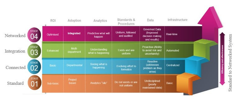
Figure 4: Maturity Model of Land Administration
(Source: Geospatial World Analysis)
Automated systems, such as land title systems and digital cadastral, are increasingly being seen as an integral part of the development of the Spatial Data Infrastructure (SDI) of a nation. These systems demonstrate the potential for technology-driven evolution of land administration and cadastral systems. The world is transitioning from data-centric systems to knowledge-centric systems. Data is not the end point and the true value of data lies in its use to derive knowledge for a particular requirement. Presently, the world’s greatest challenges are related to time and place, which in turn form the essence of geospatial and location data. Thus, geospatial knowledge is crucial for solving the world’s greatest challenges. It is, therefore, important to place geospatial knowledge at the heart of tomorrow’s sustainable digital society. Existing national spatial infrastructures need to evolve on the same grounds. An integrated and geo-enabled land administration and management system can act as an enabler for the evolution of national geospatial infrastructures, wherein lies the concept of GKI.
Geospatial Knowledge Infrastructure (GKI) aims to develop a unified infrastructure and approach which brings together these disparate elements and places geospatial knowledge at the heart of the land administration ecosystem. The evolving challenges associated with the dynamic and ever-expanding landscape of land administration necessitate a cognitive approach to the workflow. It can be achieved through the integration of frontier technologies like IoT, AI, ML, 5G etc. with geospatial data and technology. This will enable the establishment of an automated, collaborative, and participatory land administration system. The cognitive approach which places geospatial knowledge at the heart of the land administration workflow will make real-time geospatial knowledge accessible to all the stakeholders leading to effective decision-making.
GKI will certainly change the way businesses have functioned traditionally. It will democratize the power of location technology leading to a significant boost in productivity, increased efficiency and better visibility and forecasting ability of the organization. Within cadastre there is a lot of data generated in-house, enabling opportunities for enriching and delivering the data and integrating with the national data frame for developmental goals. This change in thought process will lead to an evolution of business and collaboration models as well. For effective and efficient land management, GKI can provide collaborative architecture; enrich the data ecosystem; enhance its value proposition by offering knowledge services; and integrate data for the national good.
GKI aims to bring together the stakeholders (government, industry, research, academia etc.) from the geospatial, digital, and user industries to evolve strategies and action plans to make fit-for-purpose geospatial data and knowledge accessible on demand for use cases across sectors. It will thus enable a better understanding of the needs and demands of the land administration sector through extensive engagement and interaction with stakeholders. The insights gained from these consultations can be utilized for the co-creation of fit-for-purpose products which meet the demands of the users. The co-creation of the product will also be enabled through GKI through better collaboration with an expanding geospatial ecosystem. Collaboration with the private geospatial and digital industry will enable the integration of advanced technology in the workflow to meet the evolving needs of the users.


rik vip tối qua lúc nghỉ giữa giờ mình lướt thử cho biết, kiểu xem trang họ trình bày ra sao thôi chứ không có ngồi đọc kỹ, và ấn tượng đầu là mấy phần cơ bản như đăng ký đăng nhập được để tách bạch nên mắt bắt rất nhanh, khỏi phải mò lâu. Kéo xuống cũng mượt. Nhìn đỡ rối. Tiêu đề đặt rõ nên mình biết đang ở mục nào. Chữ dễ đọc nữa. Mình thích cái cảm giác mọi thứ nằm đúng chỗ, bấm vài cái là ra đúng bài cần. Có bài hướng dẫn “Tải Rikvip” nổi bật dạng heading nên vừa vào đã thấy ngay trên trang.
Tối qua QQ88 mình lướt thử lúc đang chờ đồ ăn, kiểu mở lên cho đỡ chán mà rốt cuộc lại ở lại lâu hơn dự tính. Ấn tượng đầu là trang này sắp xếp nội dung theo từng khối nhìn khá “có nề nếp”, nên mắt mình không phải chạy lòng vòng để tìm thứ cần xem. Menu đặt ngay chỗ dễ thấy, bấm qua lại mấy mục cũng nhanh, không có cảm giác bị kéo đi kéo lại như vài trang mình từng gặp (chắc do họ tối giản bớt phần rườm rà). Mình cũng thích mấy bảng thông tin dạng cột vì nó gọn và tách bạch, nhìn một cái là hiểu đang ở đoạn nào. Nói…
https://hi88.uno/ thú thật lúc mở ra mình hơi lăn tăn vì nhìn tên miền kiểu dễ làm mình đề phòng, sợ vào lại rối rắm. Nhưng lướt vài phút thì thấy trang này bày biện khá dễ chịu, không phải kiểu nhồi nhét chữ kín màn hình. Mình chỉ xem nhanh cách họ đặt thông tin cho người mới thôi, và để ý là các khối nội dung tách riêng rõ ràng, kéo xuống là nhận ra ngay phần nào đang nói chuyện gì. Cái mình thích nữa là mấy bảng dạng cột nhìn gọn, số với tiêu đề phân cách ổn nên mắt đỡ phải căng. Menu cũng nằm chỗ dễ thấy, đổi qua lại giữa các mục không…
https://qs88.sa.com/ thấy họ nói kiểu “QS88 ⚡ Trang Game Peak Nhất 2026” với cập nhật link vào trang chủ chuẩn nên mình cũng tò mò ghé qua xem thử có gì hay ho, ai ngờ đọc lướt lại thấy cách họ sắp xếp chữ nghĩa khá dễ theo dõi, mình chỉ xem mấy đoạn giới thiệu ngắn thôi chứ không có ngồi đọc hết; có chi tiết họ ghi thành lập năm 2020 ở London thì mình nhớ mang máng vậy, coi như biết thêm một mẩu thông tin. Kéo xuống là các khối nội dung tách rõ. Chữ vừa phải nên mắt đỡ mỏi. Menu đặt chỗ dễ thấy nên chuyển mục nhanh, không phải bấm lòng vòng. Nói…
cakhia yv so với mấy trang mình từng xem bóng đá trước đây thì đỡ mệt hơn hẳn, kiểu mở lên là thấy luồng trận ngay chứ không bị chặn bắt tạo tài khoản hay điền linh tinh. Mình hay coi trên điện thoại lúc ngồi đợi việc, nên cái kiểu giao diện gọn gàng, có mấy khối nội dung xếp rõ ràng nhìn phát hiểu luôn cũng tiện ghê (đỡ phải mò menu). Có lần mạng mình hơi cà giựt, may là trên trang thường có nhiều server để đổi qua lại nhanh, không phải cứ reload tới lui như hên xui. Dĩ nhiên xem miễn phí nên chất lượng lúc lên lúc xuống tuỳ đường truyền, nhưng thao…